Unmanned Aerial System
Vertical Take Off & Landing Fixed Wing Drone – G-Wing VTOL Forward Wing
Fixed Wing Drone – Talon Fixed Wing Specification

Geo Sense Talon Fixed Wing Specification (customization):
| Body material : | EPO with Plywood & Reinforced |
| Length : | 1,100 mm |
| Wing Span : | 1,718 mm |
| Weight With pay load : | 4.5 kg |
| Autopilot type : | APM / Pixhawk |
| Motor Spec : | High torque brushless |
| Battery power : | LiPo 4s 16,000 mAH |
| Propeller Spec : | APC 12″ x 8″ |
| Flight time : | Up to 90 min |
| UAV Altitude Capability : | 500 ft to 2500 ft (180m to 500m) |
| UAV Operational Altitude : | 1000 ft (320 m) |
| Average Total Per Flight Distance : | 100 km |
| Telemetry Distance : | 5 km |
| Telemetry Options | 2.4-2.5 Ghz, 915/433 MHz |
| Ground Control: | Mission Planner |
| Mapping coverage area per 40 min flight mission : | 3 – 5 km2 or 300 – 500 ha. per flight mission |
| Navigation System : | GPS, GLONASS, BEIDOU |
UAV Specification – Cropcam Drone (usage from 2008 to 2011)

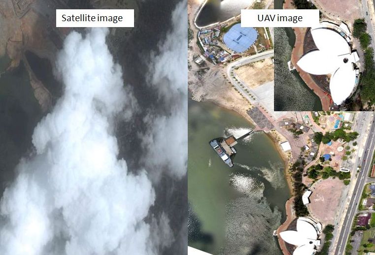
Comparing Satellite Image & Drone Imagery:

- Cloud Free Imagery – one of the problem relying satellite images in Malaysia and other tropical countries are cloud as satellite imagery unable to penetrate area with cloud cover. UAV able to fly below cloud capturing better resolution and faster or much timely delivery.

- Faster Delivery – comparing to ordering new tasking satellite imagery, average take 3 months, UAV can deliver within days or weeks.
- Easy setup – Geo Sense UAV can be setup within 30 min to fly and highly mobilise.
- Min. coverage order from satellite imagery is 100 km2. UAV or drone imagery can be programmed to cover from few acres to 3,000 acres within a day capturing.
- Battery operated, thus more environmentally safer to operate and less noise than manned aircraft.
- Computerized Geo Coordinated Log Flight Plan – enable customer to assign periodic or interval flight using as the same log flight to take the same exact area over a period of time for progress monitoring, auditing etc.
- Aerial Video Recorder – able to view live or recorded aerial video of the coverage areas for further monitoring.
- Experience Team – Need trained, experienced and certified drone operator.
- Cost versus benefits – for limited area coverage, UAV provides cheaper cost compare to conventional aircraft equipped with aerial camera. Eg. Average deploying aircraft with airborne camera is approximately RM80,000.00. Average chartering helicopter is from RM8,000.00 per day to RM25,000 (rate 2015).
Limitation
- Coverage – mini UAV is battery operated and can only cover average 3 sq km in 60 min flight, which requires to land and change battery for subsequent flights. Thus for 1 team operation, drone operator can only cover approx. 25 sq km per day.
- Compare to more than 50 sq km using conventional aircraft.
- Satellite image normally comes in standard 25 to 100 sq km with 70-80% cloud free.
- Geo Sense UAV is only equipped with normal compact RGB camera that is connected to autopilot system. Thus with limited band colour, advance analysis for remote sensing purposes are also limited. There is also option to equip with Near Infrared especially for agricultural monitoring etc. Wherelse using aircraft client able to carry more heavy sensor such as LIDAR etc.
- Strong wind condition – our glider based UAV can resist up to 30 km per hour wind to maintain stable and quality images for easy processing.
Add Value Services
- Using latest remote sensing software, the images can be processed for orthophoto thus enable users to make advance analysis such as estimation of land mass, elevation model etc.
- Special sensor can also be mount on the UAV for various colour bands reflectance analysis, for quality land analysis, vegetation analysis etc.
- Value added services may require an upgrade to our existing UAV platform.
